| View previous topic :: View next topic |
| Author |
Message |
oscar_voss

Joined: 27 Jul 2008
Posts: 622
Location: Arlington VA
|
 Posted: Tue Feb 17, 2009 8:30 am Post subject: Posted: Tue Feb 17, 2009 8:30 am Post subject: |
 |
|
That continuation of YT2 would also include a short segment in BC, which the Milepost identifies as BC2 (there might be another BC2 elsewhere in the province).
You could do same with YT3 (spur from Alaska Hwy. at Haines Junction), which also passes through BC to become AK7 into Haines. Of course, once hitting Haines, AK7 continues on a hop, skip, and jump down the panhandle, with fragments in Juneau, Petersburg (probably), and Ketchikan linked only by ferry, and some confusion on where those fragments begin and end. |
|
| Back to top |
    |
 |
admin
Site Admin

Joined: 13 Jul 2008
Posts: 4053
Location: Maryland
|
|
| Back to top |
|
|
yakra

Joined: 30 Jul 2008
Posts: 2600
Location: Area Code 207
|
| Posted: Wed Feb 18, 2009 7:12 pm Post subject: |
|
|
Keeping AK98 in the canp/all section just rubs me the wrong way; seems counterintuitive. Some users may be confused or have trouble finding it.
OTOH, It's not a select state route *freeway*... |
|
| Back to top |
|
|
oscar_voss
Joined: 27 Jul 2008
Posts: 622
Location: Arlington VA
|
| Posted: Thu Feb 19, 2009 11:47 am Post subject: |
|
|
[quote="admin"]Sadly Wikipedia is my best source on this, but that's YT 2 in BC. BC and YT highway designations don't always "properly" end at the YT/BC border.
http://en.wikipedia.org/wiki/List_of_British_Columbia_provincial_highways#Yukon_highways_in_British_Columbia[/quote]
I was last in the area in 1994, so I can't contradict Wiki on this one. The current Milepost guide to Alaska and northern Canada highways does identify as BC2 the BC segment of the South Klondike Highway (YT2, AK98), and also as BC4 the BC part of the Haines Highway (YT3, part of AK7). But it doesn't specifically address who does the route maintenance, or whether there are BC route markers, on either segment.
BTW, I also looked up the list for BC97. Both our list, and the Milepost, peg the northern end of BC97 and the beginning of YT1 as the westernmost Alaska Highway crossing of the BC/YT border east of Watson Lake YT, even though there are other crossings to the west and east of Watson Lake. |
|
| Back to top |
|
|
admin
Site Admin
Joined: 13 Jul 2008
Posts: 4053
Location: Maryland
|
| Posted: Thu Feb 19, 2009 1:57 pm Post subject: |
|
|
Here's what I find from the BC MoT:
http://www.th.gov.bc.ca/publications/planning/numbered_routes.htm#2
Just one BC 2 by the Alberta border, and BC 97 ending at the YT border near Watson Creek and Lower Post like you say.
And the Yukon Highway Log from their version of a MoT:
http://www.hpw.gov.yk.ca/pdf/YTHwyLogPublic1.pdf
It mentions "BC 97" and "1" for the Alaska Highway, changing at the same border crossing. So Google maps is wrong in flipping the designation at JCT YT 4 in Watson Lake.
The YT log shows "2" (but not "BC 2") for the Klondike Highway, starting at the AK/BC border.
But then it also shows "37" (not "BC 37") for the whole of 37 in both provinces, thus debunking my theory that they'd say "BC" if it was a BC designation.  BC MoT's page claims 37 up to the YT border. BC MoT's page claims 37 up to the YT border.
So I'm left with seeing BC MoT not include a Klondike BC 2 nor an Alaska Hwy. BC 1, but the in-BC portions of Klondike 2 and Alaska 1 are included in the Yukon's highway log.
I wouldn't say I've figured this out with much certainty, so if you can shed more light on the subject, please do. |
|
| Back to top |
|
|
Bickendan

Joined: 29 Jul 2008
Posts: 1018
Location: Portland, OR
|
| Posted: Thu Feb 19, 2009 4:14 pm Post subject: |
|
|
| I think I might put off finishing BC till we get this sorted out... |
|
| Back to top |
|
|
admin
Site Admin
Joined: 13 Jul 2008
Posts: 4053
Location: Maryland
|
| Posted: Sat Feb 21, 2009 2:14 am Post subject: |
|
|
Some pics from Jim Teresco:
YT 2 SB at the YT/BC border:
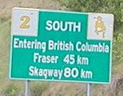
End AK 98 north & Begin YT 2 NB at the AK/BC border:
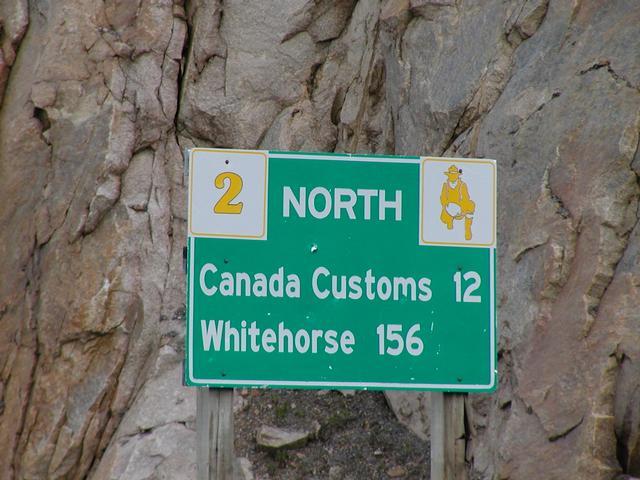
| Quote: | | Taken at the U.S.-Canada border on the Klondike Highway, looking back north into Canada. Note that this is a Yukon sign, even though this part of the road is in British Columbia. Since this road really connects the U.S. with the Yukon and only serves one town in British Columbia (Fraser), it appears to be maintained as a Yukon highway right from this point. |
http://www.teresco.org/pics/signs/
And finally I've seen what the YT highway shields should look like. |
|
| Back to top |
|
|
yakra
Joined: 30 Jul 2008
Posts: 2600
Location: Area Code 207
|
|
| Back to top |
|
|
yakra
Joined: 30 Jul 2008
Posts: 2600
Location: Area Code 207
|
| Posted: Sat Feb 21, 2009 9:31 pm Post subject: |
|
|
James Lin on YT shields:
"The signs in this column are no longer posted standalone. They are shown only in mileage signs, with the design in the upper-left corner and the number in the upper-right."
Nonetheless, maybe use these designs anyway, for the sake of just having one shield displayed in the hwy browser? Aye? Nay? |
|
| Back to top |
|
|
|

